
The park is the site of three volcanoes, one of which is now well-known for being "Mt Doom" in The Lord of the Rings. We set out on the 50km hike on the day we drove up, starting with a gentle 3 hour walk to the first hut and campsite. We set up our tent just after sunset, and could see Mt Taranaki in the distance (this was the mountain we hiked around last year, when the sole of my boot exploded!)
The second day we got up at sunrise and were on the trail by 8am, hoping to miss the hordes of dayhikers making the trip. This stretch of the trail is called the Tongariro Alpine Crossing, and is so well-advertised in Lonely Planet and beyond that it succeeds in attracting hundreds of dayhikers on any summer day.


The second day we got up at sunrise and were on the trail by 8am, hoping to miss the hordes of dayhikers making the trip. This stretch of the trail is called the Tongariro Alpine Crossing, and is so well-advertised in Lonely Planet and beyond that it succeeds in attracting hundreds of dayhikers on any summer day.
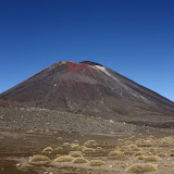
It is a beautiful trail that climbs up rocky volcanic slopes for magnificent views of Mt Ngauruhoe (pronounced something like Now-roo-ho-ee, aka Mt Doom) and the Emerald Lakes. Needless to say, being one amongst 30 people at any given point on the trail, and having loud groups of British teenagers in Converse sneakers all around you, takes away slightly from the beauty of the mountains. However, the campsite that night was nestled on golden tussock slopes overlooking Lake Taupo, and after all the dayhikers left there were just a handful of hikers continuing on the next day.

In the morning we woke to a cloud-filled valley, and re-traced our steps for an hour to meet up with the trail that continued around the mountains. We had a chance to see the red rocks, steam vents, and green lakes again without all the crowds. The rest of the day was like walking through a moonscape or desert - long exposed stretches of sand and volcanic boulders with little life except for soft lichens and energetic grasshoppers.

During the sunset that evening, we could see clouds moving in over Mt Ruapehu, in the direction of the next day's trail. Although we woke to a frosty tent and ground, we were glad to see relatively clear skies. The trail wound between the mountains, over undulating and exposed terrain. We stopped for lunch at Lower Tama Lake, formed by a crater, and made it back to the car just as dark clouds rolled overhead.

We had shared the trail with two other solo trampers - an older French woman from Paris and a young Quebecois guy from Montreal. We gave them a ride to the nearby backpacker's and then continued on our way home to Wellington. We arrived home with sun-kissed faces, sock tans, and aching muscles, and were glad to spend the windy, stormy night inside.
For more pictures of our hike, click on the picture below and it will take you to another photo album online. Once there, you can click on "slideshow" near the top left to see bigger versions of the pictures.
 |
| Tongariro Northern Circuit |

Yet once again, you've posted a great set of gorgeous shots! (The extra 24 are terrific - love the flowers, the sky shots, the tussock grass!) It's so nice that you find the energy and take the time upon getting home to share this with us all. I'd be tempted to succumb to tiredness, or all the busy work to unpack. (Mom just hopes I take a shower when I get back from an outing. She'll put up with unopened sacks for days.) Anyway, it's really nice that you do this, and fun to see more and more of New Zealand and places you are getting to.
ReplyDelete